Lighthouse Finder is your daily iPhone and iPad companion at sea and when planning your trip. Navigational aids are essential for safe navigation at sea. Especially at night, the characteristics of the aids are the basis for a reliable orientation.
Lighthouse Finder provides all relevant information on lighthouses, radio beacons and DGPS stations - worldwide. The information is based on the widely used Maritime Safety Information (MSI) database. This database provides the most complete and accurate information on aids to navigation.
Views
Lighthouse Finder displays lighthouse, radio and DGPS station information as a list or on a map.
List
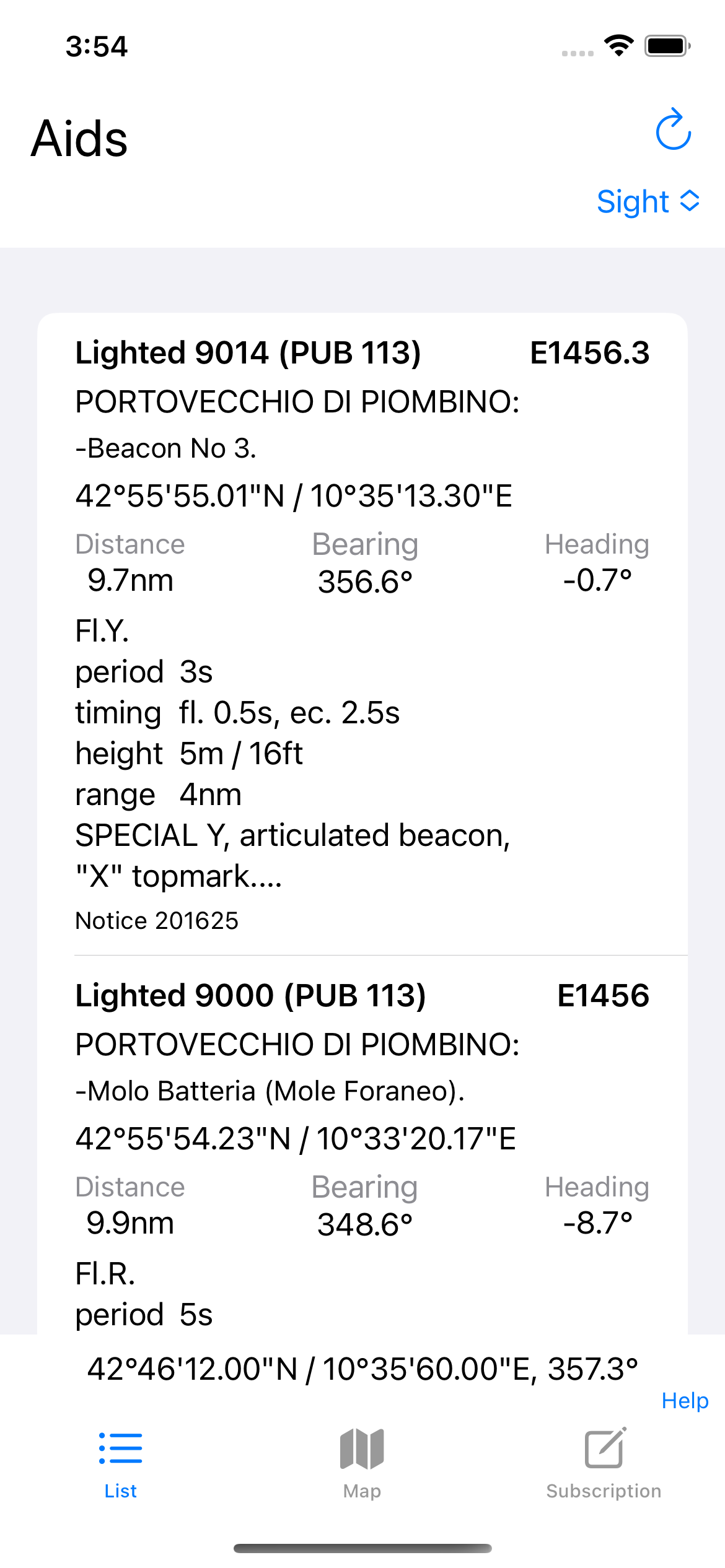
The list shows lighthouses, radio beacons and DGPS stations in tabular form with all relevant information. Distance, course and direction are also shown. The course is the absolute direction on the map from your current position to the beacon. The heading is the deviation of the heading from the orientation of the iPhone. A negative deviation means the beacon is to the left of the iPhone axis, a positive deviation to the right of the axis. While heading is useful for navigating the chart, direction can be used to locate a beacon on deck.
The list can be sorted by Id / Publication, Distance or Beacons in view. The first two sorting options are obvious. Sorting by field of view takes into account not only distance but also heading. So a beacon that is further away, but in the direction of the iPhone, may appear higher in the list than a beacon that is closer, but behind the direction of the iPhone. If you rotate your iPhone, you will need to re-sort the list using the blue rotation arrow. The number of beacons is limited when sorting by distance and direction.
Map

The map view displays beacons, radio beacons and DGPS stations on a map. In accordance with international nautical chart conventions, beacons are shown with a star and radio beacons and DGPS stations are shown with concentric circles. Depending on the level of detail of the chart, navigational aids are grouped for clarity and shown with a circle indicating the number of navigational aids included.


Selecting the marker opens detailed information about the navigation aid. In the case of combined navigation aids, the included aids are displayed.
The map can either follow the current position and orientation of the iPhone, or it can be moved freely. In the first case, the current position and orientation are shown at the bottom; in the second case, the coordinates of the map centre are shown. You can toggle between the two using the arrow in the top left corner.
Note that a working internet connection is required to use the map.
Subscriptions

The beacons, radio beacons and DGPS stations are divided into different regions. The information is subscribed monthly per region and updated regularly.
The navigation aids are subscribed to individually per region on a monthly basis. The subscription is automatically renewed. Regions are assigned according to publications.
Use the spin arrow to reload subscriptions.
Payments
Once you confirm your purchase, your payment will be charged to your iTunes account.
Unless you turn off auto-renewal at least 24 hours before the end of your current subscription period, your iTunes account will be charged again when your subscription automatically renews at the end of your current subscription period.
You can manage or disable auto-renewal at any time after purchase in your Apple ID account preferences.
Privacy Policy
Please refer to the Privacy Policy to find out how your personal information will be used.
Regions and Publications

Publications include navigation aids within geopolitical regions.
Publication 110
- Greenland
- The East Coasts of North and South America (excluding Continental U.S.A. except the East Coast of Florida)
- The West Indies
Geopolitical Heading
- Argentina
- Aruba (N.)
- Bahama Islands
- Belize
- Bermuda
- Bonaire (N.)
- Brazil
- Canada (East Coast)
- Cayman Islands
- Chile (East Coast)
- Colombia (East Coast)
- Costa Rica (East Coast)
- Cuba
- Curacao (N.)
- Dominican Republic
- Falkland Islands (Islas Malvinas)
- French Guiana
- Greenland
- Guatemala (East Coast)
- Guyana
- Haiti
- Honduras
- Jamaica
- Leeward Islands
- Lesser Antilles
- Mexico (East Coast)
- Nicaragua (East Coast)
- Panama (East Coast)
- Puerto Rico
- Suriname
- Trinidad And Tobago
- Turks And Caicos Islands
- United States (East Coast)
- Uruguay
- Venezuela
- Windward Islands
Publication 111
- The West Coasts of North and South America (excluding Continental U.S.A. and Hawaii)
- Australia
- Tasmania
- New Zealand
- The Islands of The North and South Pacific Oceans
Geopolitical Heading
- Alaska
- Antarctica
- Australia
- Bismarck Archipelago
- British Columbia
- Canada (West Coast)
- Chile (West Coast)
- Colombia (West Coast)
- Costa Rica (West Coast)
- Ecuador
- El Salvador
- Fiji Islands
- Guatemala (West Coast)
- Hawaiian Islands
- Iles De La Societe
- Iles Tuamotu
- Mexico (West Coast)
- New Caledonia
- New Hebrides
- New Zealand
- Nicaragua (West Coast)
- North Pacific Islands
- Panama (West Coast)
- Papua New Guinea
- Peru
- Solomon Islands
- South Pacific Islands
- Tasmania
- United States (West Coast)
Publication 112
- Western Pacific and Indian Oceans including the Persian Gulf
- Red Sea
Geopolitical Heading
- Andaman Islands
- Arabian Sea and Gulf of Aden
- Bangladesh
- Brunei
- Burma
- Cambodia
- Chagos Archipelago
- China
- Cocos Islands
- Comoro Islands
- Comoros
- Egypt (Red Sea)
- Ethiopia
- Gulf Of Aden
- Gulf Of Oman
- Ile Amsterdam (Fr.)
- Iles Crozet (Fr.)
- Iles De Kerguelen (Fr.)
- India
- Indian Ocean
- Indonesia
- Iran
- Japan
- Kenya
- Korea
- Kuril Islands
- Madagascar
- Malaysia
- Maldives
- Mauritius
- Mozambique
- New Guinea (Ind.)
- Nicobar Islands
- North Korea
- Okinawa Gunto
- Oman
- Pakistan
- Papua New Guinea
- Persian Gulf
- Pescadores Islands
- Philippines
- Red Sea
- Reunion (Fr.)
- Rodrigues Island
- Russia (Western Pacific)
- Ryukyu Islands
- Sakhalin
- Seychelles
- Singapore
- Somalia
- South Africa (Indian Ocean)
- South China Sea
- South Korea
- Sri Lanka (Ceylon)
- Taiwan
- Tanzania
- Thailand
- United Arab Emirates
- Vietnam
Publication 113
- The West Coasts of Europe and Africa
- The Mediterranean Sea
- Black Sea
- Azovskoye More (Sea Of Azov)
Geopolitical Heading
- Acores (Azores) (P.)
- Albania
- Algeria
- Angola
- Arquipelago Da Madeira (Madeira Islands) (P.)
- Arquipelago De Cabo Verde (Cape Verde Islands)
- Azovskoye More (Sea of Azov)
- Benin
- Bulgaria
- Cabinda
- Cameroon
- Cape Verde
- Congo
- Corse (Corsica) (F.)
- Croatia
- Cyprus
- Egypt (Mediterranean Sea)
- Equatorial Guinea
- France
- Gabon
- Georgia
- Ghana
- Greece
- Guinea
- Islas Canarias (Canary Islands) (S.)
- Israel
- Italy
- Ivory Coast
- Lebanon
- Liberia
- Libya
- Malta
- Mauritania
- Monaco
- Montenegro
- Morocco
- Namibia
- Nigeria
- Portugal
- Romania
- Russia (Black Sea and Azovskoye More (Sea of Azov))
- Sardegna (Sardinia) (I.)
- Senegal
- Sicila (Sicily) and adjanct Islands (I.)
- Sierra Leone
- Slovenia
- South Africa (West Coast)
- South Atlantic Islands
- Spain
- Strait of Gibraltar
- Syria
- The Gambia
- Togo
- Tunisia
- Turkey
- Ukraine
- Western Sahara
- Zaire
Publication 114
- British Isles
- English Channel
- North Sea
Geopolitical Heading
- Belgium
- Channel Islands (U.K.)
- Denmark (North Sea)
- England
- France (English Channel)
- Germany (North Sea)
- Ireland and Northern Ireland
- Republic Of Ireland
- Scotland
- The Netherlands
- Wales
Publication 115
- Norway
- Iceland
- Arctic Ocean
Geopolitical Heading
- Foroyar (Faeroe Islands) (D.)
- Iceland
- Jan Mayen (N.)
- Norway
- Russia (Arctic Ocean)
- Svalbard
Publication 116
- Baltic Sea with Kattegat
- Belts and Sound
- Gulf of Bothnia
Geopolitical Heading
- Denmark (Baltic Sea)
- Estonia
- Finland
- Germany (Baltic Sea)
- Latvia
- Lithuania
- Poland
- Russia (Baltic Sea)
- Sweden
Geopolitical Headings